nameless beauty

Djupavogshreppur.jpg
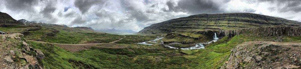
River and Waterfalls Along Djupavogshreppur

We notice in the distance a few cars pulling off to the left of the road, drivers hopping out in swimsuits in piercing cold, gingerly stepping along graveled paths.  Glacier-melt river meanders along the edge of the Ring Road as we pull over to explore, well zipped up in our insulated coats. Greg walks along the riverbed hiking close to the waterfall where hearty swimmers disappear beyond steep vertical cliffs obscuring the cascading waters. He balances carefully on rounded boulders, as I do the same walking in the opposite direction to get a wider view of the river and turquoise falls peeking out from the precipice. We are unrepentant in our obsession with waterfalls and undeterred by repeated stops to get our fix. I search the guidebooks, and later the Internet, to find images and a name for this beautiful falls and roadside river to no avail. The only information is the GPS tag on my cellphone: Djupavoshreppur. So many waterfalls, so little time, and I realize as I write this post, so few names to encompass this ever present beauty. I think about the joy of being near creeks as a child – I don’t remember their names either. Catching frogs along the creeks feeding Mendon Ponds, then later playing along Irondequoit Creek in Ellison Park. Now I live across from Second Valley Creek. I wince at the lack of imagination for the geology of my current neighborhood. First Valley and Second Valley are the places names of our town. First Valley Creek and Second Valley Creek the names of our lovely waterways on the Tomales Bay watershed. Possibly nameless beauty is a kinder way.

dirt road vistas

FallsBESTFolaldafoss on the Oxi Pass

We travel north from Hofn and take the Oxi Pass climbing up and around mountain switchbacks with stunning views behind of fjords receding in the distance. Emerald green summer kisses the jagged outcroppings of rocky mountainsides. The dirt road along this section is rutted and rough but worth the stunning views. Near the top, we pass directly across from Folaldafoss, one of several significant falls along the great eastern river Berufjardara. The 54-foot falls plummets to a pool and winds back toward Berufjordur in white calligraphic strokes across the impossible green of summer grasses. Greg sleeps quietly in the passenger side of the car as I stop repeatedly to get increasingly better views of the falls and the atmospheric perspective of receding fjords. The brilliant turquoise of glacier-melt rivers and waterfalls continues to dazzle. We stop at the uppermost vista point and get out to watch colors of water, impossible to capture in still photography, and simply drink in the experience. We are transfixed by zoom lenses that take us closer to cerulean stupor. As the video link promises, it truly is one of the most beautiful routes in Iceland.

EastFallsMtnRoad_Folaldafoss
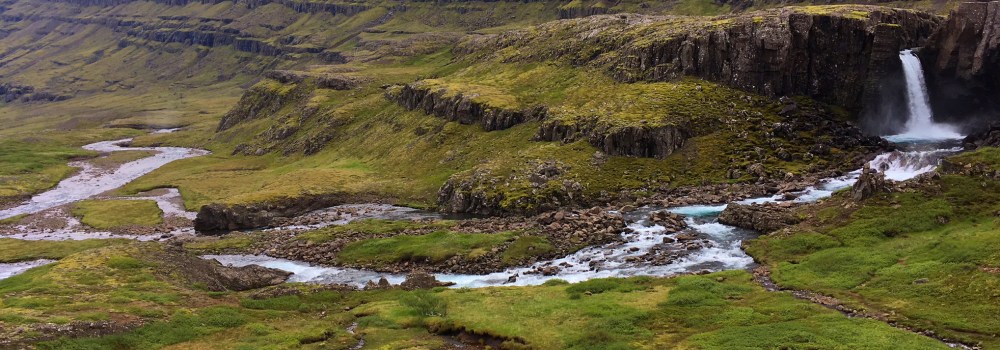
Zoom Lens of Cerulean Pools

in and out of fjords

1_EasternRoadFyodursPanoLand Falls Away Into Water

Day 4 on the road we are on the rollercoaster ride of the Austerlands. Up and down, around and back, weaving through the eastern fjords beneath the shadows and peaks of great volcanic mountains. Sun breaks out sparingly as blue skies appear intermittently through billows of gray and white clouds. We stop constantly, as around every turn, a new view, another waterfall, a mountain with breathtaking height, or peaks lost in the wrinkled sheet of clouds. I am guessing that many pass by the chance to drive the long eastern road because they assume “there is nothing there,” translated as the presence of towns and gifts stores – and they would be right in that paradigm. In fact the eastern shore is teaming with geologic and geographic wonders. We drive the roads in isolation and savor every magnificent view.

1_EasternFyodursClearingAusterlands Fyodurs Wrap Around Mountains


austerland entry

Farmstay_Eastlands
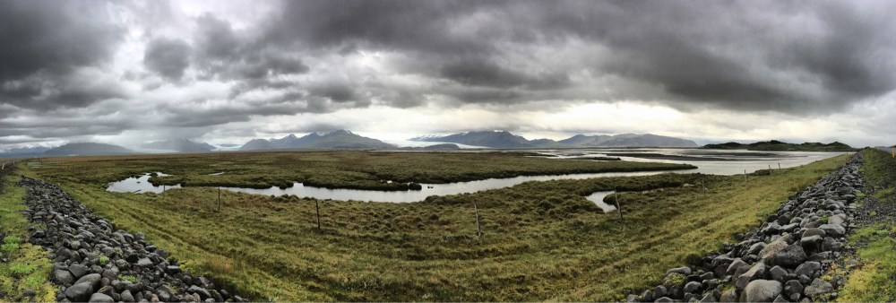
Austerland tributaries & mudflats stretching out beyond Vatnajokull

It’s close to midnight by the time we round the eastern tip and follow the curving bend of peninsula facing the opposite side of Vatnajokull, still obscured by snow and clouds, to our farmstay. We bask in the hallucagenic energy of sun still up, daylight through the night. Our host is not happy about staying up to give us the keys to the guestroom beside the barn. She is familiar with light-drunk Americans straggling in at midnight. She must surely be used to tourists waylaid and delayed by the stunning beauty of nearby Jokulsarlon Glacial Lagoon. We collapse into bed in Stafafell, across a channel of tidal mudflats facing the national park. It is hard to believe that we are only on day 3 of our trek (day 2 for me, having missed the first farmstay in Akurholt). Greg falls into bed and sleeps in his clothes as I scan the several thousand photos from the first few days in Iceland. I cannot turn my eyes away from this plethora of beauty. I walk outside in the iridescent midnight light and take several photos of the farmstead. Clouds still obscure the view of Vatnajokull’s mighty peaks. Even in morning, as sun clears more of a view the highest peaks are still hidden in mists. While Greg goes in for breakfast, I stroll about the farm composing the colors of light and ice as sunshine reveals more contours of mountains across the mudflats, the grays of frost-flecked stones brushed to the side of the driveway, the textures of Icelandic horses against green grass pastures extending to the water’s edge. We are forgiven by a gracious host who has provisioned a lovely breakfast of eggs, waffles, fruits, with traditional skyr & granola. We are voracious for  food as well as for contours of culture; collections of stones and shells along a windowsill, tidy rows of shoes and coats in the foyer, a cross-eyed four-horned goat proudly beheaded and displayed in the dining room. Raised in the Northeast, I am well acquainted with the practicality of foyers as air locks against the cold, as mudrooms to mitigate the rain and slush of incessantly inclement weather. Refreshed from food and sleep we trek along the gravel path back to our room in the light of late morning, so similar to that of past midnight. We unplug our chargers, pack our bags, provision snacks and water for the car, and drive off into Austerland as the Eastern Coast is known. Few tourists travel this coast and we are grateful to have the roads and vistas all to ourselves.

GuesthouseEast

birthplace of giants

Iceland_Glacier Lagoon2
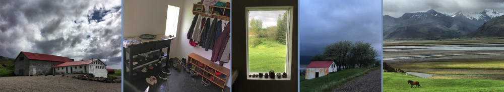
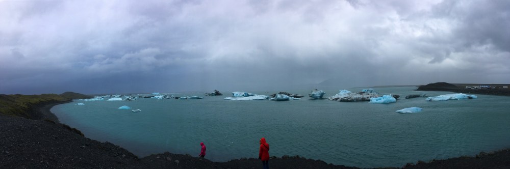
Jokulsarlon Glacial Lagoon in June 2017

We are worn down by the weather after numerous stops in biting cold along the sandur, ready to forge on to our farmstay along the eastern coast. Fortunately other visitors signal the path to the most amazing site in Iceland. As we pass through a whiteout of winds and snow, a few brave souls bundled in winter jackets cut in and out of the looming white ice dunes crowding the edge of the road. We strain to see what the attraction might be and take the left fork at the next turn. We are stunned by beauty: Jokulsarlon, the glacial lagoon, arctic nursery for icebergs calving off Fjallsjokull and Vatnajokull glaciers. There are not enough names for the colors of glacial blue! Shades of turquoise, sapphire, azure and every ultramarine in the cool spectrum are pressed and radiant in layers of ice. This is an experience that will thrill us over and over again throughout Iceland – the unique bevy of blues from glacial melt. The lagoon meanders into Jokulsa to the sea populated by raucous flocks of gulls, skuas, and arctic terns, all haggling for territory. It is the shortest river in Iceland, looking more like a channel. Icebergs may float about the lagoon for up to five years before making the short transit to the ocean. The geography seems ancient, yet the lagoon is merely 80 years old. In the 1930’s Breidamerkurjökull, a tongue of the great Vatnajökull Glacier came right up to the Ring Road. The lagoon is growing at a staggering 500 meters per year due to glacial melt from climate change. Barely visible across the expanse of water are the two large tracks trailing off Breidamerkurjökull. Breidamerkurfjall Mountain is an offshoot of Iceland’s largest mountain, Öræfajökull. This congregation of glaciers and mountains comprise Vatnajokull National Park Iceland’s largest park in the Skaftafell region, where most Icelanders head for vacation. The storm obscures the majestic peaks, but we pull on sweaters, coats, hats, gloves, everything we’ve got and step out into the storm, snow blowing horizontally, to absorb the views. A few tour boats bustle tourists closer to the glacier pack. We prefer the grand view, the vista of calving tracks across the translucent bay, the distance to take in animate melodies of rushing waters and pelagic birds. The colorist in me delights when two figures in shocking red coats step into my composition of blues for complimentary balance. We stay as long as we have feeling in our fingertips. Breathing in beauty, framing it in photographs, capturing it in video. We collapse into the car exhausted from the cocktail of cold and beauty, another 50 kilometers to go to our farmstay. Hours among glaciers is worth the delay.

GlacierLagoonSet4blogColors of blue at Jokulsarlon Glacial Lagoon in the middle of a snowstorm in June.

surreal surroundings

Sandur4blog2
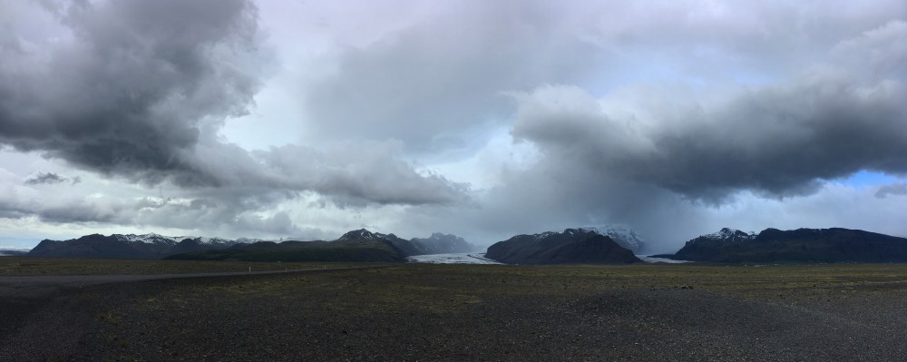
Glacial Outwash of Skeiðarársandur in the Southeast

Most tourists travel only the Southshore to Vik and turn back. If you continue east, one of the most fascinating geographies of the planet greets you in a flat expanse of sand, boulders, and bracken that can survive this cold, wet, shifting landscape. Skeiðarársandur is the largest glacial outwash, sandur, in the world. It’s formed from the massive deposits from the grand Skeiðarárjökull glacier and spreads out across the southern plain meandering to the Atlantic coast. Beneath angry grey clouds we traverse the spectacular geology of sandur encompassing 1300 square kilometers that on a map looks like a massive expanse of spider veins tangling toward the sea. The road rambles along for nearly 50 kilometers of flat, rocky, roiling terrain. Windblown with heavy clouds most of the way, we are glad for the comfort of a car, as bicyclists and a motorcyclist huddle against rock outcrops to shelter from the fierce winds and rain. The guidebook describes this section as “a cyclist’s nightmare.” We stop at the Skeiðará Bridge monument of twisted I-beams from the 1996 eruption of Vatnajokull that erupted and melted with massive flash flooding that rolled 100-2000 ton blocks of ice across the vast glacial tributaries that make up the Skeiðará that flows to the sea. It is estimated that the 100-200 ton ice blocks crumpled the highway like matchsticks. The evidence is in the grotesquely twisted girders forming the monument that waffle and twist like paper strips rather than the most durable construction metal on the planet. Sun breaks out and contrasts the deepening grey edges of arctic clouds rimming Skeiðarárjökull. A lone skua lands and considers us as we read the signs from the displays at the washed out bridge. Reference guides to the sandur describe it in unflattering terms: “tormented, soul-destroying, and barren.” In its own history, after a similar volcanic eruption and flooding in 1362, the region was referred to as Öræfi, or Wasteland. We enjoy the luxury of 21st C sheltered tourists appreciating the glorious geology that humbles human pursuits.

Sandur Set2Arctic winds scour the sandur with fierce winds amid isolated farmsteads, calving glaciers, bowed tourists, and ruined bridges.


on the road

Iceland_On The Road1South Shore on the outskirts of Rangarping Eystra

On the road. Such an interesting phrase – Jack Kerouac made it famous. We pantomime it (in a more environmental context) every few miles. Drive. See an amazing geology: waterfall, river, mountain range, rock pile. Stop. Get out – literally get “on the road.” Walk around. Choose vantage points. Greg is a delightful traveling companion. He enjoys the several dozen stops as much as I do and doesn’t complain that we essentially travel at an average speed of 20 mph or less averaging photo stops. What pushes me to ecstasy in Iceland is the shifting blankets of clouds blowing fiercely across the vast sky. We travel in June – prime tourist season – and yet rarely see another car on the road. We keep to the paved pullouts, aware of the egregious destruction by tourists pulling off the road into pristine landscapes. The verdant green expanse is intoxicating. The colors remind me of California in winter, which enjoys a Mediterranean climate. Parched yellow-beige of dead grasses from late spring, summer, and most of autumn erupt into this vermillion shade of green as winter rains influenced by El Nino/La Nina tropical weather patterns inspire the landscape to burst into life for a few short months. Too soon in Caliofornia, drought returns and colors fade. Not so in Iceland, evergreen even in winter as grasses are buried beneath the snow. I think of childhood snowstorms in upstate New York and the delight of digging deep into snowdrifts to uncover the still green landscape, frozen and brittle. Traveling Iceland in summer we bask in the ever present, luminous greens of arctic winds softened by warm ocean currents. Always at hand are insulated jackets, as winds blow clouds through at a ripping rate, rain ever looming from jagged edges of scud clouds.  Even the season’s strongest sunshine cannot warm ubiquitous arctic winds.