 Dyrhholaey Cliffs West of Vik – Day 3
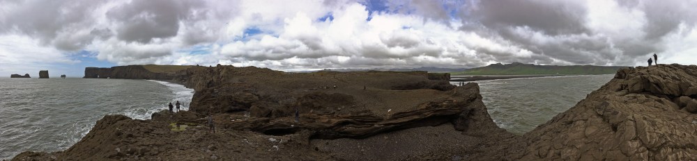
We head east again along the Ring Road and drive across the narrow peninsula to the nature reserve of Dyrholaey, arcing out from the mainland. We look back directly across to the farmhouses dotting the virulent green of the South Shore. Mounting the cliffs secures a spectacular view of the elemental wonders of a different geology – earth uplifted, after our ice excursion. These cliffs are composed of rock from submarine volcanic eruptions 100,000 years ago made of tuff , volcanic ash ejected from underwater vents during eruption, eventually compacted into solid rock containing bedrock, tephra, and volcanic ash all ground into one impressive cliff. This “haey” or high island consists of tuff while the eastern “lagey” or low island is composed of dolerite, basalt, and labradorite. One landmark feature includes a promontory archway, large enough for boats to pass through, the source of its place name meaning “Door Hole Island.” In his signature navy blue winter coat, Greg treks across the center of this image exploring the surrounding geology. The view across the bay is a Tolkien wonderland. To the north the jagged peaks of the Myrdalsjokull glacier surmount the sky. To the east, the series of black lava seastacks called Reynisdrangar meander across the shoreline, and to the west spreads the black coastline of Reynisfjara Beach. Seabirds including puffins, guillemot, and razor-bill breed at the seastacks and along the headland crags of Dyrholaey. It is simply breathtaking to spend so much time in such a short distance marveling over, and walking across such accessible geology. We chose Iceland for our first bucket list travels because of these elemental features that so fascinate and allure us. Each mile continues to deliver an abundance and variety of fascinating geography.
